
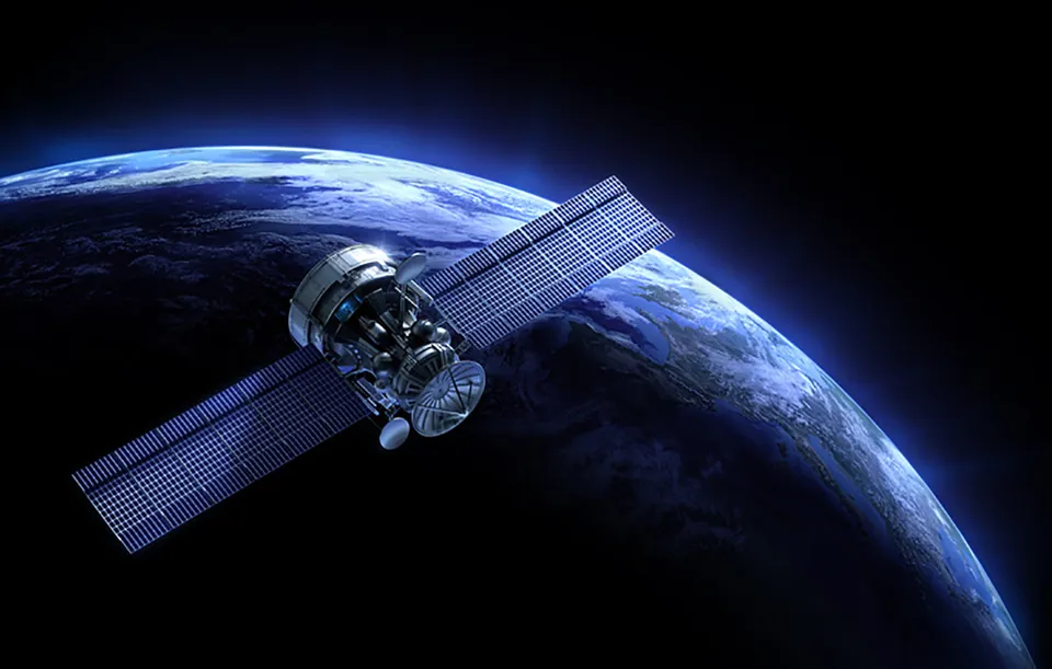
The launch of satellites for Europe’s €20 billion (£17bn) global navigation satellite system may have gone unnoticed by most fleet operators, but experts say the new, highly accurate global positioning service will change the operating landscape for fleets.
With its precise atomic clocks, the European Union (EU) and European Space Agency’s (ESA) Galileo system will deliver real-time positioning accuracy to within a metre once the initial service begins in 2014.
If there happens to be any sort of satellite failure, users will be informed within seconds, and positioning services in ‘urban canyons’ (where satellite visibility is obstructed by high buildings and skyscrapers) will increase accuracy from a typical 50% with the American GPS system, to more than 95% with Galileo, according to the European Commission’s Joint Research Centre.
Four of Galileo’s operational satellites are being launched in 2011 and 2012, with additional satellites to be launched in the following three years.
ACFO director and head of transport provision at Bracknell Forest Council, Damian James, said that while fleets may not find an immediate use for Galileo, emerging technologies currently underway in the road transport sector will certainly benefit from the enhanced accuracy of this GPS system in years to come.
James said that he believes fleet managers will begin to see the real benefits of Galileo through projects such as eCall, which will need advanced positioning systems to bring rapid assistance to motorists involved in collisions anywhere in the European Union.
The European Commission plans for this system to have EU-wide coverage by 2015. It would involve a hardware black box in vehicles wirelessly sending impact sensor information and GPS coordinates to local emergency agencies when an accident occurs.
“I think is going to have a massive impact on what we’re doing as fleet managers and the way we run vehicles in general,” said James. “For eCall to work there’s obviously a strong link with Galileo in terms of increased accuracy.
“Another area of developing technology for fleets that will benefit greatly from Galileo is the emergence of automatic and semi-automatic driving systems that need to employ the most precise GPS systems as possible.”
For example, if a vehicle is running off an automatic driving system and is approaching a corner too fast, the vehicle would need an enhanced GPS to detect that the car cannot get around the corner at that speed and would need to automatically apply the brakes.
“For an application like that, you’re going to need accuracy down to the centimetres, and that’s where I really see Galileo coming to the fore, with automatic systems that are going to be on vehicles in 10 to 15 years’ time,” said James.
And these driving systems might be available to fleet managers sooner rather than later. German manufacturer Volkswagen has already developed the Temporary Auto Pilot (TAP), which, monitored by a driver, would allow a car to drive semi-automatically at speeds of up to 80 mph on motorways, starting from 2016. Volvo has also developed a prototype called Automated Queue Assistance (AQuA), which would support truck drivers in traffic congestion using numerous sensors that monitor the surroundings and make decisions autonomously.
TAP and AQuA were both developed as a part of the EU-funded research and development project HAVEit (Highly Automated Vehicles for Intelligent Transport), established to develop technologies for highly automated driving.
It has involved 17 partners from the European automotive industry and scientific community since February 2008, with total investments amounting to €24 million.
In addition, while the major benefits of Galileo to fleet managers might be in the medium-term, Marc Daley, managing director of fleet management consulting firm Daley Associates, said that in the shorter-term, their niche applications will be useful.
“Highway maintenance activities such as gully emptying and salting of roads definitely would benefit from a more accurate GPS system,” he said.
Reaching for the stars
The fully-deployed Galileo system will consist of 30 satellites (27 operational ones along with three active spares), positioned in three circular Medium Earth Orbit (MEO) planes at 23,222km altitude above the Earth and they will be controlled though two ground operation centres, near Munich, Germany, and in Fucino, Italy.
The development of state-of-the-art applications for Galileo is supported by the annual European Satellite Navigation Competition. This year, California-based Making Virtual Solid won the title of ‘Galileo Master 2011’ with their navigation system True3D; designed to provide non-distracting, translucent location guidance via a red “virtual cable” projected directly on to the windscreen of a car.


Login to comment
Comments
No comments have been made yet.