
Local authorities in the north are being helped to address a regional divide in electric vehicle (EV) charging infrastructure by identifying those in most need.
New information on driveways is being generated by Transport for the North (TfN), in partnership with Ordnance Survey (OS).
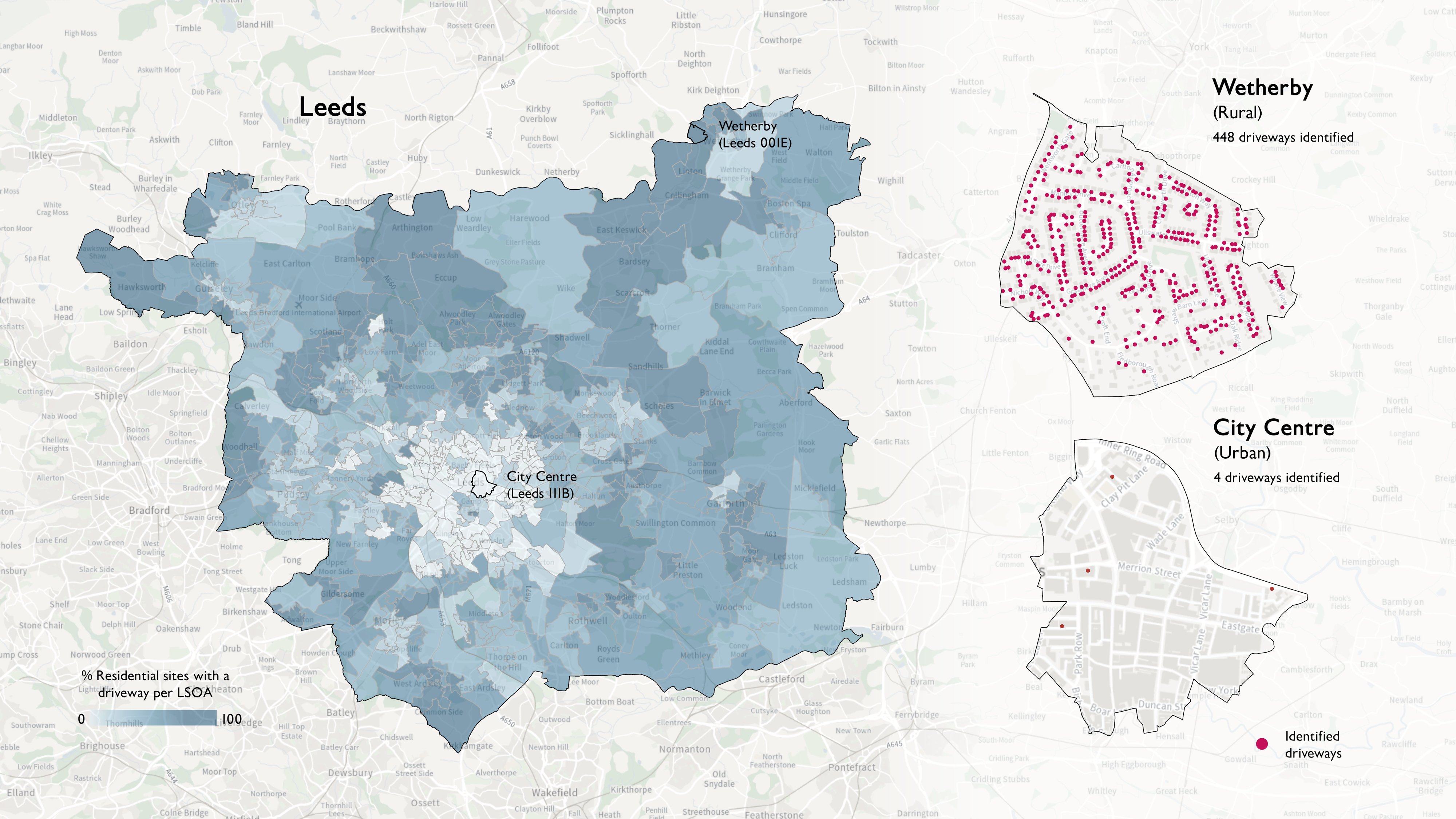
They have developed a model through machine learning to identify which of the 6.4 million households in the region have driveways, or off-street parking access, and therefore the potential for access to chargers at home.
Those people living in properties without off-street parking are at a significant disadvantage both in terms of cost of charging EVs and accessibility.
The new analysis can now help councils target specific areas which do not have access to charging facilities and better plan, monitor and forecast where there is public need.
A recent report by the Public Accounts Committee highlighted that 43% of all charge points are hosted in the South East and London.
TfN’s recent EV State of Play report revealed that the north has a higher proportion (47%) of households without driveways, compared to the national average (40%).
The new analysis has also highlighted some significant differences within regions in the TfN area. For example, in the North East, one road in Sunderland has more than 500 homes but only 12% of them have driveways.
A more extreme example is in the North West, where a road with more than 190 houses has only one with a driveway.
Aggregated driveway data can be accessed via TfN’s online visualiser.
Household-level data has been shared with requesting local authorities across the north, from Cumbria and Northumberland to Cheshire and Greater Manchester.
OS and TfN have now undertaken to expand the pilot project nationally via all sub-national transport authorities across England.
Chief customer officer at OS, John Kimmance, said: “This latest partnership with Transport for the North has provided vital insight which will help local authorities in the region plan their EV infrastructure more effectively.
“While this will benefit the public in ultimately gaining greater access to EV charge points in the future, it will also potentially save local authorities thousands of pounds.”
There are more than 17,500 public charge points available in the region, more than double the number two years ago. But TfN’s projected requirements show that at least a tenfold increase could be needed by the end of the decade, with 178,000 to 240,000 public charge point plugs required across the north of England.
The roll-out of the Local Electric Vehicle Infrastructure (LEVI) fund now means that £109 million is available across the region to support local authorities with improvements to public charge point provision.
Simon McGlone, principal planning and strategy officer at Transport for the North (TfN), said: “This partnership with Ordnance Survey has maximised trusted geospatial data to improve localised intelligence across our region, boosting public sector capability to support a fair and equitable EV transition for all, whilst delivering significant savings to public spend.”
The OS Maps API was used for the basemapping, supplemented with data from the Land Use and Buildings themes from the OS National Geographic Database.
Building on the driveways work, OS and TfN also looked at walking catchment areas to public car parks, which could be used as potential EV charging hubs.
To achieve this, an open-source routing engine was paired with data from the OS Multi-modal Routing Network.
OS supported the project under the Public Sector Geospatial Agreement. This multi-million pound contract with government enables 6,000 public sector bodies and emergency services access to OS geospatial data for free to help with the delivery of critical and routine services.
More articles on:
 Fleet News looks in detail at how you can start the journey to van electrification and speaks to those already well advanced in their transition about the innovative ways they overcome some of the problems.
We also bust myths about batteries and look at the technologies poised to come to market promising greater range and faster charging.
Openreach head of sustainability Abby Chicken explains how the UK's largest commercial fleet is managing the transition to electric, and we also look at 10 of the best electric car and van models due to come to market this year.
Enjoy the read
Steve Briers
Group editor
Fleet News
Read now
Gareth has more than 20 years’ experience as a journalist having started his career in local newspapers in the 1990s. Prior to joining Fleet News in 2008, he worked in the public sector as a media advisor and is currently news editor at Fleet News.


 Neil Broadbank, Raw Charging, Lilian Greenwood, Transport Minister, Bianca Sammut, Merlin Entertainments, Toby Poston, BVRLA")


Login to comment
Comments
No comments have been made yet.